O-scape: free orienteering mapping software
Making maps for orienteering can be an expensive business. Being a niche market, orienteering mapping software such OCAD can prove prohibitively pricy for individuals looking to get started in mapping, plus you are restricted to being a Windows user. Going down the vector graphics route using free plugins for mainstream drawing tools, such as MapStudio for Adobe Illustrator, opens up mapping to Mac and Windows users but again proves to be expensive.
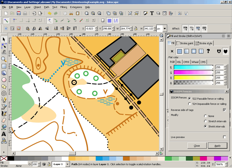
Now however we've learnt of a new option for making orienteering maps, using completely free software, available across Mac, Windows and Linux platforms. By using Inkscape, an open source cross platform vector graphics editor, coupled with an orienteering specific set of extensions - O-scape, you can now draw orienteering maps for free.
If you're used to vector drawing then you'll find Inkscape and O-Scape easy to pick up. For newcovers, vector drawing can be quite a steep learning curve, but perseverence is worthwhile and Inkscape does seem to be very intuitive to use compared to other vector drawing software.
We got in touch with Jon Eaton (WCOC), the developer of the O-scape extensions to find out more about the project.
Nopesport: What prompted your development of the O-scape extensions?
Jon Eaton: Last Christmas I spent a while searching the internet for free software that could provide a platform for the production of Orienteering maps. The search proved fruitful when I discovered Inkscape.
Inkscape is a cross-platform Open Source vector graphics editor distributed under a free software licence and can be run on Linux, Windows & Mac OSX. Inkscape has capabilities similar to Adobe Illustrator and uses the W3C standard Scalable Vector Graphics (SVG) file format. Inkscape has a deceptively simple and streamlined interface while supporting many advanced features making it very easy to edit nodes, perform complex path operations, trace bitmaps and much more. Inkscape is under active development, with new features being added regularly by a thriving user and developer community using open, community-oriented development. More information on Inkscape can be found on the Inkscape website.
Inkscape has been designed to accept extensions written in a number of programming languages and includes interpreters for Ruby, Perl and the most commonly used language for writing Inkscape extensions, Python.
I have written a set of Python extensions, the O-scape extensions that, together with the innate capabilities of Inkscape, enable the full symbol set of ISOM:2000, ISSOM:2007 and the new ISMTBOM:2010 to be created. The O-scape extensions are now available on SourceForge.net at: sourceforge.net/projects/o-scape/files/.
Nopesport: What is the benefit of using Inkscape and the O-scape extensions?
Jon: Being FREE, Inkscape and the O-scape extensions will hopefully enable individuals and small clubs to create maps where they were previously unable to afford the software required. Also, this could provide the mapping tool to enable orienteering to spread into more areas and countries.
Nopesport: What are your future plans for O-scape?
Jon: Currently Inkscape and the O-scape extensions cannot generate pictorial control description tables although a full set of the control description symbols is available. This is a gap that I hope to fill in a future update. Inkscape can, though, output high resolution PNG files, providing compatibility with Condes and Purple Pen.
Simple instructions are currently provided to get people started using Inkscape and the O-scape extensions. It is my intention to a write a comprehensive manual to describe the best ways of using the O-scape extensions with Inkscape.
Other areas where I'm looking to make developments include a routine for generating random dot patterns to automatically produce regions of symbol 117 Broken Ground and 210 Stony Ground and the ability to import Ocad files into Inkscape (if at all possible).
This is the first release of the O-scape extensions and is, as such, untested in the real world. Therefore, I would appreciate feedback of any comments that you may have and that may improve the operation and performance of the extensions.
If you want to get involved in the project, find out more about O-scape on SourceForge or get in touch / send feedback at: o_scape@btinternet.com or discuss this on the Nopesport forums.
So, now we've got free map drawing through O-scape, you can now use entirely free software from start to finish of putting on an event. Draw the map using O-scape, use Purple Pen to plan your courses, then use Ór to manage entries and results on the day.
While we believe there is orienteering software out there that is worth paying for, free options help open up the sport to individuals and small clubs who can't afford the cost of software. This hopefully will also force the developers of commercial software to stay on top of their game in improving their work and meeting the needs of their userbase, before they opt for the free route.
If you've got any other interesting orienteering technology or software news get in touch, we're always interested to find out more about possible means to develop the sport using new technology.
Nopesport relies on user submitted articles. Got an inside scoop? An event review? Please submit it to us.

Nope News
Podcasts
Orienteering headlines from around the web:
Winsplits
World of O
Bof News
Nopesport is supported by these advertisements